
קובץ:Ssxiso.gif

גודל התצוגה המקדימה הזאת: 800 × 522 פיקסלים. רזולוציות אחרות: 320 × 209 פיקסלים | 640 × 418 פיקסלים | 924 × 603 פיקסלים.
לקובץ המקורי (924 × 603 פיקסלים, גודל הקובץ: 39 ק"ב, סוג MIME: image/gif)
| זהו קובץ שמקורו במיזם ויקישיתוף. תיאורו בדף תיאור הקובץ המקורי (בעברית) מוצג למטה. |
תקציר
| תיאור |
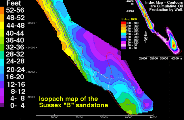
English: Isopach map of the Sussex "B" sandstone showing thickness in feet of the interval between bounding disconformities; contour interval is 4 ft (1.2 m). Map scales are meters. The small index contour map is cumulative oil production; contour interval is 40,000 barrels. The thin red line outlines the boundary of the House Creek field. Thin white lines in the southern half of the field are limits of sand-ridge 1 and overlying sand-ridge 2.
|
|||
| מקור | http://pubs.usgs.gov/dds/dds-033/USGS_3D/ssx_gif/ssxiso.gif | |||
| יוצר | USGS |
רישיון
This image is in the public domain in the United States because it only contains materials that originally came from the United States Geological Survey, an agency of the United States Department of the Interior. For more information, see the official USGS copyright policy.
|
היסטוריית הקובץ
ניתן ללחוץ על תאריך/שעה כדי לראות את הקובץ כפי שנראה באותו זמן.
| תאריך/שעה | תמונה ממוזערת | ממדים | משתמש | הערה | |
|---|---|---|---|---|---|
| נוכחית | 07:51, 14 ביולי 2008 | | 603 × 924 (39 ק"ב) | דקי | {{Information |Description={{en|1=Isopach map of the Sussex "B" sandstone showing thickness in feet of the interval between bounding disconformities; contour interval is 4 ft (1.2 m). Map scales are meters. The small index contour map is cumulative oil pr |
שימוש בקובץ
הדפים הבאים משתמשים בקובץ הזה: