
קובץ:Mahan Problem of Asia 1900.png
לקובץ המקורי (1,357 × 353 פיקסלים, גודל הקובץ: 33 ק"ב, סוג MIME: image/png)
| זהו קובץ שמקורו במיזם ויקישיתוף. תיאורו בדף תיאור הקובץ המקורי (בעברית) מוצג למטה. |
תקציר
| תיאור |
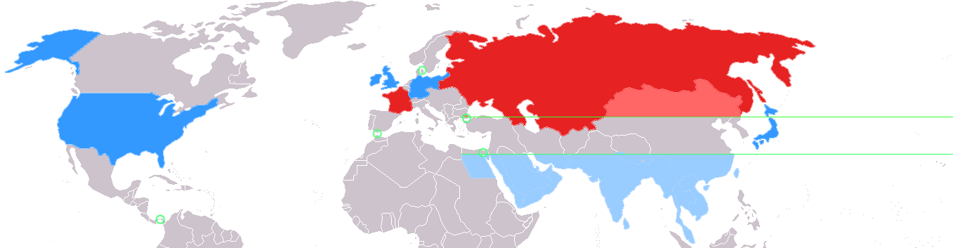
English: This map depicts the world as divided by geostrategist Alfred Thayer Mahan in his 1900 piece The Problem of Asia.
Asia is divided along the 30 north and 40 north parallels, represented here by green lines. Colored in red are the two allied land powers, the Russian Empire and France. In lighter red are the portions of Asia above the 40th parallel under effective influence of Russian land power. Colored in blue are the four allied sea powers, Great Britain, the German Empire, Japan, and the United States. In lighter blue are the portions of Asia below the 30th parallel subject to effective control by sea power. In between the 30th and 40th parallel is what Mahan termed the "Debatable and debated ground," subject to competition between the land powers and sea powers. Circled in green are key isthmuses identified by Mahan: the Suez Canal, Panama Canal, Turkish Straits, Strait of Gibraltar, and Danish Straits. SourceCreated by myself, user:Perceval, using the :Image:BlankMap-World-WWI.PNG. |
| תאריך יצירה | 22 בדצמבר 2006 (תאריך העלאה מקורי) |
| מקור | הועבר מ- en.wikipedia לוויקישיתוף. |
| יוצר | Perceval מוויקיפדיה האנגלית |
רישיון
| היצירה הזאת שוחררה לנחלת הכלל על־ידי היוצר שלה, Perceval מוויקיפדיה האנגלית. זה תקף בכל העולם. יש מדינות שבהן הדבר אינו אפשרי על פי חוק, אם כך: Perceval מעניק לכל אחד את הזכות להשתמש ביצירה הזאת לכל מטרה, ללא שום תנאי, אלא אם כן תנאים כאלה נדרשים לפי החוק. |
יומן העלאה מקורי
| תאריך/שעה | ממדים | משתמש | הערה |
|---|---|---|---|
| 2006-12-22 04:06 | 1357×353× (27252 bytes) | Perceval | This map depicts the world as divided by [[geostrategy|geostrategist]] [[Alfred Thayer Mahan]] in his 1900 piece ''[[The Problem of Asia]]''. [[Asia]] is divided along the 30 north and 40 north [[latitude|parallels]], represented here by green lines. Co |
היסטוריית הקובץ
ניתן ללחוץ על תאריך/שעה כדי לראות את הקובץ כפי שנראה באותו זמן.
| תאריך/שעה | תמונה ממוזערת | ממדים | משתמש | הערה | |
|---|---|---|---|---|---|
| נוכחית | 22:14, 15 במרץ 2022 | 353 × 1,357 (33 ק"ב) | Randomastwritter | added dervish state | |
| 00:09, 6 בספטמבר 2015 | 353 × 1,357 (27 ק"ב) | Matanya | Transferred from en.wikipedia |
שימוש בקובץ
הדף הבא משתמש בקובץ הזה:
שימוש גלובלי בקובץ
אתרי הוויקי השונים הבאים משתמשים בקובץ זה:
- שימוש באתר en.wikipedia.org
- שימוש באתר ja.wikipedia.org