
קובץ:Borders proposed by the Count of Aranda.svg

לקובץ המקורי (קובץ SVG, הגודל המקורי: 983 × 639 פיקסלים, גודל הקובץ: 3.39 מ"ב)
| זהו קובץ שמקורו במיזם ויקישיתוף. תיאורו בדף תיאור הקובץ המקורי (בעברית) מוצג למטה. |
תקציר
| תיאור |
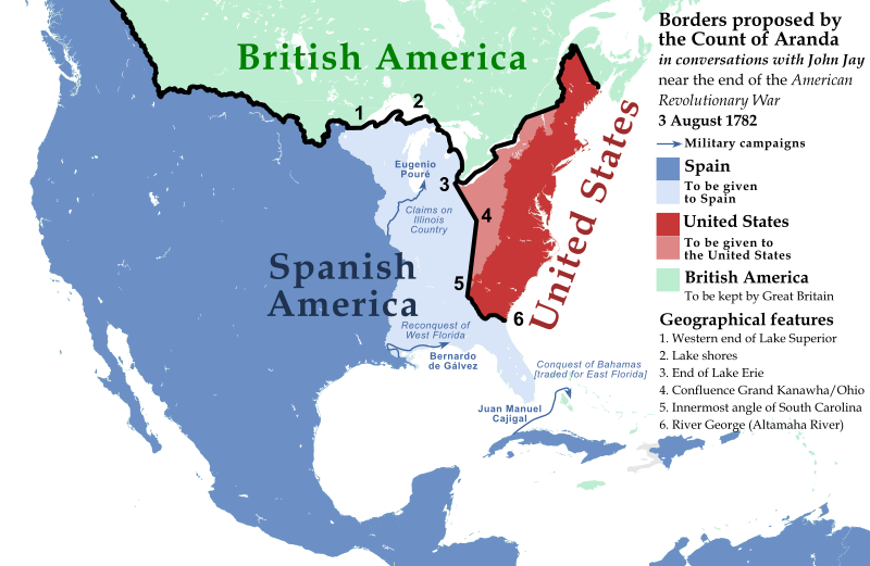
English: North American borders proposed by the Count of Aranda in conversations with John Jay near the end of the American Revolutionary War, 3 August 1782
Español: Fronteras de Norteamérica propuestas por el Conde de Aranda en conversaciones con John Jay cerca del final de la Guerra de Independencia de los Estados Unidos, 3 de agosto de 1782 |
| תאריך יצירה | |
| מקור |
Sources: BASE MAP: File:United_States_(US49+1),_administrative_divisions_-_XY.svg Negotiations for Peace (Complete Map), 1779-1783 [PLATE 89], Atlas of the Historical Geography of the United States http://dsl.richmond.edu/historicalatlas/89/ See Line 5. The Rayneval Memoranda of 1782 on western boundaries and some comments on the French historian Doniol, by Samuel Flagg Bemis. American Antiquarian Society, April 1937 https://www.americanantiquarian.org/proceedings/44806951.pdf "Let us start at the western end of Lake Superior and follow the lake shores along as far as the end of Lake Erie or Oswego. These are positions which cannot leave lands back of them in dispute." [...] "Now we will drop the line down to the confluence of the Grand Kanawha with the Ohio," he continued, "thence to the apex of the innermost [i.e. westernmost] angle of South Carolina, so as to continue the demarcation toward some outstanding point, say a lake [Ou the Mitchell's Map used by the negotiators there is single lake near the boundary of East Florida, about 83° west longitude.], in the Apalache country, or the river George [the Altamaha river], without however going all the way, simply marking the beginning of the line so as to indicate it would go that way. We would have to stop before we get to the boundary of Georgia or of Florida until we know what their real boundaries are." Altamaha River is chosen in this representation. Pouré, Gálvez and Cajigal expeditions are shown due to their influence on the Spanish proposal. Rupert's Land claimed border is also represented (Hudson Bay watershed) and taken as the Spanish-British border. British America-US border is shown as in many other representations of the early US. |
| יוצר | Nagihuin |
,_administrative_divisions_-_XY.svg)
רישיון
| קובץ זה זמין לפי תנאי הקדשה עולמית לנחלת הכלל CC0 1.0 של Creative Commons. | |
| האדם ששייך יצירה להיתר הזה הקדיש את היצירה לנחלת הכלל על־ידי ויתור על כל הזכויות שלו או שלה על היצירה בכל העולם לפי חוק זכויות יוצרים, לרבות כל הזכויות הקשורות או הסמוכות כקבוע בחוק. באפשרותך להעתיק, לשנות, להפיץ, או להציג את היצירה, אפילו למטרות מסחריות, וכל זה אפילו מבלי לבקש רשות.
|
היסטוריית הקובץ
ניתן ללחוץ על תאריך/שעה כדי לראות את הקובץ כפי שנראה באותו זמן.
| תאריך/שעה | תמונה ממוזערת | ממדים | משתמש | הערה | |
|---|---|---|---|---|---|
| נוכחית | 19:17, 1 באוגוסט 2019 | | 639 × 983 (3.39 מ"ב) | Nagihuin | Corrected old Maine borders. |
| 03:20, 28 ביולי 2019 |  | 639 × 983 (3.39 מ"ב) | Nagihuin | User created page with UploadWizard |
שימוש בקובץ
הדף הבא משתמש בקובץ הזה:
שימוש גלובלי בקובץ
אתרי הוויקי השונים הבאים משתמשים בקובץ זה:
- שימוש באתר en.wikipedia.org
- שימוש באתר uz.wikipedia.org
- שימוש באתר vi.wikipedia.org